Spatial analysis
Formal techniques studying entities through spatial properties.

Spatial analysis refers to formal techniques that study entities using their topological, geometric, or geographic properties. It is primarily used in urban design and includes a variety of approaches, especially spatial statistics. The field has applications in astronomy, chip fabrication engineering, genomics, and most notably in geospatial analysis of geographic data.
- field
- Spatial analysis, cartography, surveying, spatial statistics
- known_for
- Techniques for studying entities via topological, geometric, or geographic properties; fundamental issues such as the boundary problem and modifiable areal unit problem
- applications
- Urban design, astronomy, chip fabrication, epidemiology, ecology, economics, remote sensing, computer science
Lore & Background
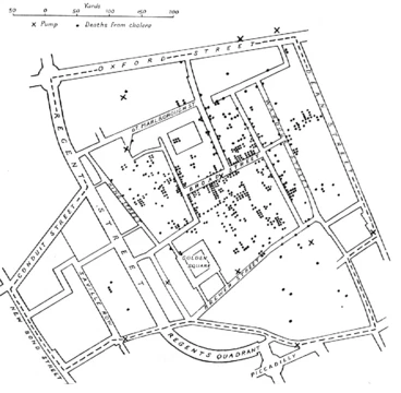
Spatial analysis began with early cartography and surveying. Land surveying dates back to at least 1,400 B.C. in Egypt, where taxable land plots were measured with ropes and plumb bobs. Many fields contributed to its modern form: biology through botanical studies and ethology; epidemiology through disease mapping, notably John Snow's cholera outbreak map; statistics through spatial statistics; economics through spatial econometrics; geographic information systems through software; remote sensing through morphometric and clustering analysis; computer science through algorithms and computational geometry; and mathematics through fractals and scale invariance.
Reader's Guide
Spatial analysis confronts fundamental issues in defining objects of study, constructing analytic operations, using computers, and presenting results. Common errors arise from the mathematics of space, data presentation, and available tools. Census data aggregated into local units raises statistical issues. The fractal nature of coastlines makes precise length measurement difficult; computer software fitting straight lines to a coastline may produce lengths with no inherent meaning. These problems are challenging because maps combine generally accurate spatial data with potentially inaccurate analytic results, creating an impression of greater accuracy. Spatial dependence—the relationship of variable values or locations across space—is measured through spatial correlation, covariance functions, and semivariograms. Methods like Kriging are used for spatial interpolation. Spatial dependency leads to autocorrelation problems in statistics, violating assumptions of independence. Regression analyses that do not compensate can yield unstable estimates. Spatial heterogeneity means overall parameters may not describe processes at any given location. Spatial association is the degree to which things are similarly arranged in space, analyzed through map overlay and regression.
Did You Know?
- Land surveying goes back to at least 1,400 B.C. in Egypt, using measuring ropes and plumb bobs.
- John Snow's mapping of a cholera outbreak is an early example of spatial analysis in epidemiology.
- The fractal nature of coastlines makes precise length measurement difficult or impossible.
- Spatial analysis is applied in fields as diverse as astronomy, chip fabrication engineering, and genomics.
Foundations: Extending the Relational Database with Geometry
A spatial database takes the familiar relational database and extends it to handle objects defined in geometric space. While a conventional database manages numeric and character fields, a spatial one adds dedicated geometry or feature data types so that points, lines, and polygons can be stored as attribute values in a table. More advanced systems go further, accommodating three-dimensional objects, topological coverages, linear networks, and triangulated irregular networks. Because every geographic location must be expressed within a spatial reference system, these databases also track and transform coordinate systems; when a spatial column is created, the developer typically selects a coordinate system from a lookup table. The datatypes in most implementations trace back to the OGC Simple Features specification, first released in 1997, which established the common language for representing geometric primitives. Some systems additionally support raster data alongside vector geometries, broadening the range of spatial information a single database can hold.
Query Power: Spatial Operations Inside the SQL Language
The second major extension a spatial database adds to a traditional system is a rich set of spatial operations embedded directly into the query language. In most relational database management systems, these appear as new functions callable within SQL SELECT statements, giving analysts the same analytical power once confined to dedicated GIS software. The OGC standard specifies several categories: measurement functions that compute line lengths, polygon areas, and distances between geometries; geoprocessing operations that modify existing features to produce new ones, such as buffering or intersecting; predicates that return true or false answers about spatial relationships like overlap or containment; geometry constructors that build new shapes from specified vertices; and observer functions that extract specific properties, such as the center of a circle. In practice, a free extension like PostGIS for PostgreSQL exposes these as functions—ST_Distance, ST_Contains, ST_Centroid, ST_Intersection—so a spatial join between a city-points layer and a country-polygons layer can be written as a single extended SQL statement, replicating core GIS overlay operations without leaving the database.
Spatial Indexing: Taming Multi-Dimensional Lookups
Traditional database indexes sort values in a linear order, which works well for alphabetical or numeric lookups but breaks down when the data lives in two- or three-dimensional space. Spatial databases therefore rely on dedicated spatial indexes that implement multi-dimensional access methods. A long list of techniques has emerged: binary space partitioning trees that subdivide space with hyperplanes, bounding volume hierarchies, geohashes, grid-based indexes, Hilbert R-trees, k-d trees, octrees, quadtrees, and various R-tree variants including the R+ tree, R* tree, UB-tree, and X-tree. The R-tree family is typically the preferred approach: objects such as shapes, lines, and points are grouped using minimum bounding rectangles, and a new object is inserted into the rectangle whose size increases the least. Other methods like the m-tree target similarity queries on complex objects using arbitrary metrics, while PH-trees and Z-order curves offer alternative strategies for multi-dimensional ordering. Choosing the right index is critical because it determines how quickly a spatial database can answer location-based questions across millions of features.
Standards, Vendors, and the Geodatabase Ecosystem
The growth of spatial databases has been shaped by a small number of influential standards bodies and a broad ecosystem of vendors. The Open Geospatial Consortium, through its Simple Features specification released in 1997, set the baseline for how geometric primitives should be represented and how spatial functions should behave across different systems. The SQL/MM Spatial standard, part of the broader ISO/IEC structured query language and multimedia framework, extends Simple Features further, embedding spatial capabilities more deeply into the SQL language itself. On the application side, a geodatabase is essentially a georeferenced spatial database purpose-built for storing and manipulating geographic data within GIS environments. Almost every current relational and object-relational database management system now ships with a spatial extension, and several GIS software vendors have developed their own proprietary spatial extensions to complement or extend those provided by the database engine. This layered ecosystem—standards bodies, database vendors, and GIS toolmakers—means that spatial analysis can now be performed inside the database itself rather than requiring data to be exported to a separate mapping application.
Frequently Asked Questions
What is Spatial analysis in the GIS canon?
Spatial analysis is a set of formal methods that examine objects or phenomena through their topological, geometric, or geographic characteristics. It draws on cartography, surveying, and spatial statistics, and functions as a core analytical discipline within the broader GIS framework.
What is Spatial analysis most known for?
The field is recognized for rigorous techniques that study entities via their spatial properties, especially spatial statistics and geometric operations. It also tackles foundational challenges such as the boundary problem and the modifiable areal unit problem, which shape how researchers define and aggregate spatial data.
Where does Spatial analysis show up outside of mapping?
Beyond its flagship role in geospatial analysis of geographic data, the techniques are applied in urban design, astronomy, chip fabrication engineering, epidemiology, ecology, economics, remote sensing, and computer science. This cross-disciplinary reach makes it one of the most versatile quantitative tools in modern research.
How does Spatial analysis differ from GIS as a whole?
GIS is the broader platform for capturing, storing, and visualizing geographic data, while spatial analysis is the reasoning layer that applies formal statistical and geometric methods to extract patterns from that data. In short, GIS supplies the toolkit and spatial analysis supplies the analytical logic.
Why is Spatial analysis considered central to the GIS community?
It provides the methodological backbone that converts raw geographic data into explanatory insight, whether that means modeling disease spread, optimizing city layouts, or detecting patterns in genomic sequences. Without its formal frameworks, spatial data would remain largely descriptive rather than predictive.
Spotted an error? Know more?
This is a living reference — every entry is fact-audited, and reader corrections feed straight into our audit queue. Suggest an edit · See this site's audit record